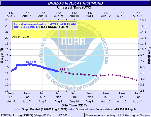
The Brazos River in Richmond is at Gage Elevation 14.29 feet and falling. We have minor rain chances throughout the week, but rainfall amounts are generally low. The 7-Day Quantitative Precipitation Forecast (QPF) is showing the lower Brazos River Watershed receiving less than ¼ inch of rain over the next 7 days. Based on the current forecast, no flooding due to the Brazos River through Fort Bend County is anticipated.
See the attached Flood Risk Report.
Tropical Weather Outlook
The National Hurricane Center is tracking 2 Disturbances in the Atlantic, Disturbance No. 1 (Invest 94L) and Disturbance No. 2 (Invest 93L). Below is a summary from HCFCD this morning on Invest 94L.
Strong tropical wave (94L) currently approaching Barbados this morning.
An area of elongated low pressure that moved west over the weekend from the western end of the monsoon trough over the eastern and central Atlantic is nearing the Windward Islands this morning. Radar from Barbados along with satellite images show a broad and elongated area of low pressure with scattered to numerous areas of disorganized convection. The system lacks current organization to be declared a tropical depression. 94L is moving generally W to WNW at around 10mph and this motion will continue with a sprawling sub-tropical high located over the central and southwest Atlantic inducing a general E to ESE steering flow. This is supported by the major global models guidance and much of the ensemble products which bring 94L along much of the Lesser Antilles Island chain over the next 5 days. Details on the exact track will be important as to determine how much the system will interact with the island chain. Overall guidance keeps 94L on the weak side through the period likely due to land interaction and dry air that surrounds the system to the north.
The NHC currently has development odds into a tropical cyclone at 70% over the next 5 days.
While the system is currently no immediate threat to the Gulf of Mexico, residents should at least keep an eye on the forecast for updates over the next week.
Please let us know if you have any questions or need additional information.