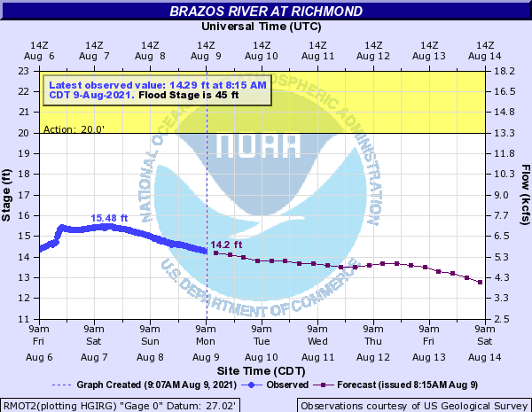
As of 8:15 AM on June 17, 2024, the Brazos River in Richmond
is in Action Stage and is currently at Gage Elevation 33.2 feet. This morning’s
forecast shows the Brazos River in Richmond dropping below Action Stage toward
the end of the week. Please note that the current forecast only includes
rainfall over the next 24 hours. The watershed is expecting additional rainfall
to occur through Wednesday which could result in changes in the current
forecast.
Over the weekend, the National Hurricane Center’s forecasts included a broad area of low pressure forming over the Bay of Campeche. Infrared satellite imagery for the Western Atlantic indicates a tropical air mass advancing along the Texas coast bringing a plume of increased moisture across the central Gulf of Mexico. This is expected to reach the region tonight into early Tuesday morning. Forecast guidance suggests the potential for varying degrees of development of a notable surface low pressure system in the western Gulf of Mexico later today into tonight. Despite uncertainties in development, impacts are anticipated to start today along the Texas coast and worsen through Tuesday and Wednesday.
With an incoming surge of tropical moisture and favorable conditions for organized banding features, significant rainfall amounts are anticipated, particularly for areas south of I-10. The heaviest rainfall is expected from Tuesday afternoon through early Wednesday morning. Some coastal counties could see widespread rainfall amounts between 8 to 10 inches with the potential for isolated higher amounts. Across the Houston region, through Wednesday, rainfall amounts of 5 to 8 inches are possible for areas near and south of US-59 and 2 to 4 inches for areas north of US-59. As with any tropical system, isolated areas with higher amounts are possible. Depending on where the heaviest rains occur, rises on area streams and other local drainage facilities are possible.
Forecasts and conditions can change. Everyone is encouraged to stay weather aware by following their favorite local weather source, including the National Weather Service, the National Hurricane Center, and the West Gulf River Forecast Center. If you have not ready done so, please remember to sign up for Emergency Updates from Fort Bend County.