The NWS has issued a Flash Flood Watch from this evening through Saturday evening. According to the forecast, a slow moving upper low pressure system should move through the region with the potential of producing widespread heavy rainfall. The most severe areas, which includes parts of Fort Bend County, could potentially receive between 3 to 4 inches of rain with isolated amounts exceeding 6 inches over the next 24 hours with rainfall intensities between 1 to 3 inches per hour. The lower Brazos River watershed from Waco to Freeport could receive widespread rainfall amounts between 2 to 3 inches.
From Jeff Lindner with the Harris County Flood Control District:
A strong storm system will move across SE TX on Saturday with a complex of thunderstorms likely to develop and move slowly across SE TX. Parameters will be in place for heavy to excessive rainfall as this complex of storms crosses the area. Deep tropical moisture combined with a diffluent upper air patter aloft, and warm rainfall processes all point to excessive short term rainfall rates of 1-3 inches per hour. Line of storms may slow as it near and moves south of the I-10 corridor Saturday afternoon and this would only increase the flash flooding threat.
Rainfall amounts on Saturday will average 1-3 inches with isolated totals of 6 inches or more. Much of this rainfall will fall in a short period of time maximizing run-off potential. While grounds are not particularly wet, the potential for intense rainfall rates will likely produce a high street flooding threat. Rises on area creeks and bayou will also be possible. Most creeks and bayous will be able to handle the 1-3 inches, but if the 6 inch isolated totals fall over certain watersheds, then some flooding would be possible.


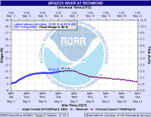
Based on the current forecasts, the latest WGRFC data shows the potential for a Minor to Moderate river event occurring within the Brazos/Navasota Watershed. This is only a forecasted potential scenario and not an immediate flood threat from the Brazos River. The extents and specific location(s) will depend on the final rainfall amounts received. The WGRFC latest forecast shows the Brazos River in Richmond rising to at least Gage Elevation 18.2 feet, but could enter Action Stage toward the end of the week. We will continue to watch this system and the conditions throughout the weekend.


The immediate threat from this event is the possibility of flash flooding within streets and our smaller drainage systems. Our major channels could experience rapid rises leading to flooding along those streams; however, the impacts to larger facilities and the Brazos River will vary depending on the actual rainfall amounts and intensities. We encourage everyone to follow good flood safety standards and stay informed through trusted sources such as the National Weather Service, Harris County Flood Control, and the Fort Bend County Office of Homeland Security & Emergency Management.