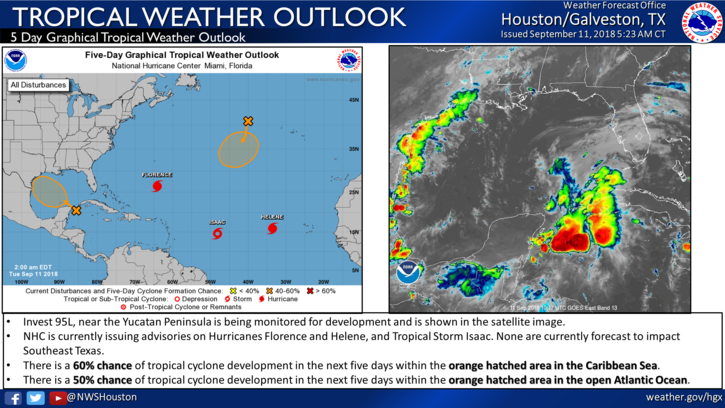

Tropical cyclone formation remains possible for the NW Gulf of Mexico late this week.
Residents along the TX coast should closely monitor the progress of this system and have hurricane plans and kits in place.
There has been little change in organization of the tropical wave over the Caribbean Sea overnight. Sporadic deep convection continues to develop in an near what is most likely a mid level low pressure system. Thus far there have not been any surface observations to support any surface low pressure formation. Upper level winds remain fairly strong out of the WSW/W as the system is on the eastern side of a weakening upper level trough over the central Gulf of Mexico. As this upper trough weakens and the tropical wave axis moves into the southern Gulf of Mexico upper level winds will become somewhat more favorable for the formation of a tropical cyclone.
The GFS, ECMWF, and CMC models either maintain an open tropical wave or attempt to close off a surface low pressure system along the wave axis in the Thursday and Friday period as the feature moves NW toward the TX coast. It is unclear at this point if the system will be able to close off a surface low, but development chances increase as it nears the TX coast late this weekb�&so things can and will likely change quickly on Thursday and Friday.
Regardless of actual development of a closed low pressure system the main impacts appear to be heavy rainfall and potential flooding. Wet and soggy grounds are already in place over much of coastal TX and additional rainfall is likely both today and Wednesday. Deep tropical moisture with the tropical feature will begin to arrive on the TX coast late Friday with bands of heavy rainfall and gusty winds spreading along the TX coast Friday and into Saturday.
At the moment it is still too early to discuss specific impacts, but the threat for heavy rainfall and potential flooding late this week into this weekend along the entire TX coast is increasing. For now will leave tides, winds, and seas alone and await better trends in any center track and intensity of the feature. Even an open wave axis will likely produce 20-30kts across the NW Gulf waters. This could be a system where much of the adverse conditions will occur to the north and east of any actual surface center.
Forecast confidence toward the end of the week and weekend is low and residents along the TX coast should closely monitor forecasts over the next few days for changes.
Short Term (Tuesday)
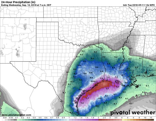
Last night the NWS extended the Flash Flood Watch until 6 PM this evening. Based on the forecasts, the heaviest rains should be generally along and south of US-59. These wet conditions will stay with us through Saturday. Much of Fort Bend and Harris Counties could see another 1 to 2 inches today with a total of 2 to 3 inches over the next 7 days. As mentioned above these rainfall amounts could vary depending on the development of Invest 95L.