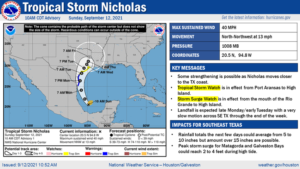
The District is continuing to watch Invest 99L. The system is currently located south of the Caribbean Island which is becoming better organized as it moves in a northwesterly direction. The National Hurricane Center anticipates the system could develop into a tropical depression or storm later today as it moves its way into the Gulf of Mexico. Over the past 24 hours, modeling has come into better agreement for possible landfall east of the Houston area along the Louisiana Coast. Please note that there is still enough uncertainty in the forecast so no one can rule out possible impacts along southeast Texas. We encourage residents to remain weather aware by following their preferred weather source (i.e. National Weather Service, Space City Weather, and Local News).
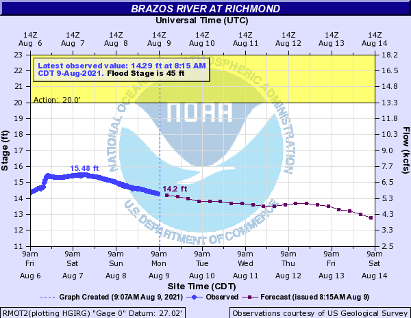
We continue to have increased rain chances over the next few days. The 3-Day Quantitative Precipitation Forecast (QPF) shows Fort Bend County possibly receiving between ½ to 1 inch of rain over the next 3 days. The extended forecast (beyond 3 days) continues to be heavily influenced by the development and track of Invest 99L. We still have increased rain changes in the extended forecast, but with the path trending toward Louisiana the rainfall totals for the next 7 days have decreased over the past 24 hours. Currently, the 7-Day QPF is showing the lower Brazos River Watershed receiving between 0.10 to 3 inches of rain over the next 7 days with Fort Bend County potentially seeing 1.5 to 3 inches of rain over the next 7 days. Based on the current forecast, no flooding due to the Brazos River through Fort Bend County is anticipated.
Please let us know if you have any questions or need additional information.